Community-based Exercise to Prepare a Socioenvironmental Baseline Map of Coastal, Mangroves and Farmland Areas Proposed to be Covered by Cuddalore-Nagapattinam Petroleum, Chemical and Petrochemical Investment Region, Tamilnadu.
 |
Community Environmental Monitoring - A Project of The Other Media |
 |
Shweta Narayan |
 |
http://www.sipcotcuddalore.com |
 |
JPY 400,000 |
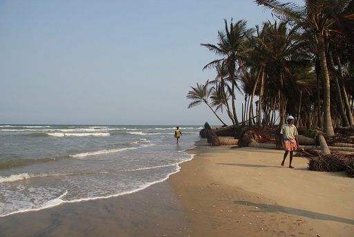
Cuddalore coast
Research Background
Maps tell the story of the mapper. The perspective is all that matters. Colonial rulers in India used maps effectively to divide the country and dispossess its inhabitants. Even today, in Independent India, lands on which multitudes of people are dependent are being acquired by branding them as wastelands, degraded forests and non-agricultural and barren lands. Expert cartography, in collaboration with the instituional and esoteric science of Environment and Social Impact Assessments are increasingly being deployed by a Government and Private Sector that is pushing through with a radical program of industrialisation in India's rural hinterlands and the coast. In devaluing the lands, and in ignoring the multifaceted links that indigenous and agrarian communities have with their lands, waters and seas, the dominant hegemony finds a justification in dispossessing them of their lands in return for "development through industrialisation." It is little wonder then that in place after place in India, industrialisation has met with steadfast resistance from people. If maps can dispossess, they can well be deployed to retain community control over resources. As late cartographer Barney Nietschmann wrote "More indigenous territory can be reclaimed and defended by maps than guns."
It is with such an understanding of the power of maps that Community Environmental Monitoring proposes to develop a community-based "countermap" of a 270 square kilometre section of coastal land in two districts of the Southern Indian state of Tamilnadu. The choice of this area is triggered from a potentially problematic proposal of the Government of India to convert these areas -- predominantly dependent on an agrarian/fisheries economy - into chemical and petrochemical industries as part of a grand Petroleum, Chemical and Petrochemical Investment Region.
Acquisition of 270 square kilometres of lands from reluctant Indian farmers, peasants and fishers will not be without controversy. But going by the strategies deployed by private corporations and Government agencies in other land acquisition proceedings, misinformation about the quality and utility of the lands to be acquired play a key role in creating public opinion to justify the acquisition. Lands to be acquired are frequently devalued by branding them as wastelands, barren, un-irrigated, or as of no use to anyone. In reality though, what may appear to a layperson to be a wasteland may in reality be the native scrub jungle supporting an amazing biodiversity and endemic species. What would appear to be lands of no use to anyone may be grazing lands where communities find fodder, fuelwood, medicine and other cultural meanings. Expert and foreign mappers, such as the consultants that arrive to conduct day-long appraisals of the local environment for the purposes of an Environmental Impact Assessment are likely to miss out on these important features.
The 270 square kilometres identified for the PCPIR is one such biologically and culturally diverse region. With the Bay of Bengal bounding it on the eastern side, the landward side is characterised by fertile plains, crisscrossed by rivers and streams, and dotted with numerous villages and towns, with histories dating back to the pre-Christian era.
The current application proposes to develop maps, or rather "countermaps", of the area informed by various members of the local communities, and by the various experiences of the environment by various sections of people - women, fishers, farmers, grazers, elders and medicine men/women - within these local communities. The process of gathering these information for the baseline maps will also allow Community Environmental Monitoring to make them aware of the proposed PCPIR complex and mobilise informed community opinion around the proposal. The current application proposes to not only develop community maps, but also a handbook on preparation of such community baseline maps.
The project will consist of a 2-month preparatory phase during which a reconnaissance trip of the area will be completed, and secondary data including base maps gathered and digitised. The second phase of around 6 months will consist of field visits and information gathering through focus group discussions, physical groundtruthing, surveys etc. The last four months will be devoted to reviewing the draft with the community, refining it and handing it over to the various communities for their future use and update.
Because the information will be generated based on the combined experiences of various community members, the final maps are likely to be accessible to community members. Community members are not only likely to have an increased understanding of their own local geographies, but also ofthe various ways in which different groups within their community use and value various components of the same environment. Such an understanding will leave the community stronger in the face of disinformation that may come packaged in the guise of expert or institutional science. This will also allow local people to get a stronger grip on the course of changes in their neighbourhood, be it to challenge environmentally destructive "development" projects or in demanding and securing environmentally and socially appropriate schemes.
[Sep. 2011]
Final Report (abstract)
Maps tell the story of the mapper. The perspective is all that matters. Colonial rulers in India used maps effectively to divide the country and dispossess its inhabitants. Today, in Independent India, lands on which multitudes of people are dependent are being acquired by branding them as wastelands, degraded forests and non-agricultural and barren lands.
But if maps can dispossess, they can well be deployed to retain community control over resources. It was with such an understanding of the power of maps that Community Environmental Monitoring (CEM) proposed to develop a community-based map of a 270 square kilometre section of coastal land in two districts of the Southern Indian state of Tamilnadu. The choice of this area was triggered by a potentially problematic proposal of the Government of India to convert these areas - predominantly dependent on an agrarian/fisheries economy - into chemical and petrochemical industries as part of a Petroleum, Chemical and Petrochemical Investment Region (PCPIR).
CEM's counter-mapping project proposed to develop maps of the area informed by various members of the local communities, and by the various experiences of the environment by various sections of people - women, fishers, farmers, grazers, elders and medicine men/women - within these local communities. The process of gathering these data for the baseline maps would also allow Community Environmental Monitoring to train communities in baseline mapping, raise awareness of the proposed PCPIR complex and mobilise informed community opinion around the proposal. The project proposed to not only develop community maps, but also a handbook on preparation of such community baseline maps. This document is that handbook.
During implementation, the project faced a lack of continuity in the membership of the project team (in particular, in the role of project coordinator). This lack of continuity affected various aspects of project implementation. In particular, it affected the project team's ability to build networks of allies and collaborators in the PCPIR area. Faced with this situation, the project team selected and achieved a more modest - but no less important - objective: developing a toolkit of mapping methods, a community-based map of the village of Panaiyur, and a data set (consisting of secondary data) on the PCPIR area. Having achieved this objective, CEM is now in a very strong position to take forward a community mapping exercise in the PCPIR area, utilising the techniques for collecting, analysing and mapping primary data developed in relation to Panaiyur and the secondary data already collected in relation to the PCPIR area.
[Sep. 2014]
Others